
-
![Garmin Navionics Vision+ NVSA004L -Mexico, the Caribbean to Brazil - Inland Coastal Marine Charts [010-C1285-00] - Premium Garmin Navionics Vision+ from Garmin - Just $399.99! Shop now at Brushy Creek Marine](//bcmarineproducts.com/cdn/shop/files/95933XL.jpg?v=1722925637&width=1096) files/95933XL.jpg
files/95933XL.jpg
![Garmin Navionics Vision+ NVSA004L -Mexico, the Caribbean to Brazil - Inland Coastal Marine Charts [010-C1285-00] - Premium Garmin Navionics Vision+ from Garmin - Just $399.99! Shop now at Brushy Creek Marine](http://bcmarineproducts.com/cdn/shop/files/95933XL.jpg?v=1722925637&width=1096)
Navionics Vision+™ NVSA004L - Mexico, the Caribbean to Brazil - Inland & Coastal Marine Charts
It's A Whole New Look On Your Chartplotter
Featuring vibrant colors, a streamlined interface, and combined coastal/inland content with a popular Navionics® style color palette, Garmin Navionics+ cartography makes it easy to plot your course with the world’s No. 1 name in marine mapping1.
Features:
- Navigate with our best offshore and inland lake coverage for your Garmin chartplotter.
- See it your way. Customize your view with various chart layers and overlay combinations.
- With your included one-year subscription, access daily updates via the ActiveCaptain® smart-device app.
- Auto Guidance+™ technology2 lets you navigate with suggested dock-to-dock routings.
- Select up to 10 color-shaded target depth ranges to scope out the best fishing spots.
- Save money by renewing your subscription — and continue accessing daily updates plus new content downloads.
- Access detail-rich mapping of coastal features, lakes, rivers, and more. Integrated Garmin and Navionics® content offer coverage for boaters worldwide.
- Charts are constantly being enhanced with new and amended content — as many as 5,000 updates are made every day. Your one-year subscription includes access to daily chart updates via the ActiveCaptain app.
- Combining the best of Garmin and Navionics automatic routing features, built-in Auto Guidance+ technology2 gives you a suggested dock-to-dock path to follow through channels, inlets, marina entrances, and more.
- High-resolution depth range shading lets you select up to 10 color-shaded options and view your designated target depths at a glance.
- For improved fishing and navigation, up to 1' contours provide a clear depiction of bottom structure for improved fishing charts and enhanced detail in swamps, canals, harbors, marinas and more.
- To give a clear picture of shallow waters to avoid, this feature allows for shading at a user-defined depth.
- NOAA raster cartography3 is available for some U.S. waters as a free downloadable feature via the ActiveCaptain app to provide paper chart-like views on your plotter.
- Community-sourced content provides useful POIs, such as marinas, anchorages, hazards, businesses and more. Get recommendations from boaters with firsthand experience of the local environment.
- This downloadable shading feature4 combines color and shadow to give you an easy-to-interpret, clearer view of the bottom structure than contour lines alone.
- The downloadable sonar imagery feature4 reveals bottom hardness clearly and in contrasting colors, highlighting both subtle and dramatic transition areas on select U.S. lakes.
- Downloadable high-resolution satellite imagery4 provides superior situational awareness.
- Crystal-clear aerial and surface photos of ports, marinas, bridges, docks, boat ramps, dams, and navigational landmarks provide a better sense of your surroundings above the waterline.
- Side-scan images capture submerged features such as fallen timber, fish attractors, wrecks, potential hazards, and more on select U.S. lakes.
- This underwater perspective shows a 3D representation of the bottom and contours as seen from below the waterline. Interface with sonar data for a customized view.
- This view provides a 3D representation of the surrounding area both above and below the waterline.
- Adjust your maps to the lake’s current water levels to see if spots are accessible or too shallow to explore.
1 Based on 2021 reported sales
2 Auto Guidance+ is for planning purposes only and does not replace safe navigation operations
3 Raster cartography cannot be viewed on echoMAP™ CHIRP and ECHOMAP™ Plus combos but can be viewed on mobile devices via the ActiveCaptain mobile app
4 Subscription required; a one-year subscription, which is included with the purchase of Navionics Vision+ mapping solution, lets you access daily chart updates and download additional content or premium features included with your cartography product
Garmin
Garmin Navionics Vision+ NVSA004L -Mexico, the Caribbean to Brazil - Inland Coastal Marine Charts [010-C1285-00]
- Regular price
- $399.99
Navionics Vision+™ NVSA004L - Mexico, the Caribbean to Brazil - Inland & Coastal Marine Charts
It's A Whole New Look On Your Chartplotter
Featuring vibrant colors, a streamlined interface, and combined coastal/inland content with a popular Navionics® style color palette, Garmin Navionics+ cartography makes it easy to plot your course with the world’s No. 1 name in marine mapping1.
Features:
- Navigate with our best offshore and inland lake coverage for your Garmin chartplotter.
- See it your way. Customize your view with various chart layers and overlay combinations.
- With your included one-year subscription, access daily updates via the ActiveCaptain® smart-device app.
- Auto Guidance+™ technology2 lets you navigate with suggested dock-to-dock routings.
- Select up to 10 color-shaded target depth ranges to scope out the best fishing spots.
- Save money by renewing your subscription — and continue accessing daily updates plus new content downloads.
- Access detail-rich mapping of coastal features, lakes, rivers, and more. Integrated Garmin and Navionics® content offer coverage for boaters worldwide.
- Charts are constantly being enhanced with new and amended content — as many as 5,000 updates are made every day. Your one-year subscription includes access to daily chart updates via the ActiveCaptain app.
- Combining the best of Garmin and Navionics automatic routing features, built-in Auto Guidance+ technology2 gives you a suggested dock-to-dock path to follow through channels, inlets, marina entrances, and more.
- High-resolution depth range shading lets you select up to 10 color-shaded options and view your designated target depths at a glance.
- For improved fishing and navigation, up to 1' contours provide a clear depiction of bottom structure for improved fishing charts and enhanced detail in swamps, canals, harbors, marinas and more.
- To give a clear picture of shallow waters to avoid, this feature allows for shading at a user-defined depth.
- NOAA raster cartography3 is available for some U.S. waters as a free downloadable feature via the ActiveCaptain app to provide paper chart-like views on your plotter.
- Community-sourced content provides useful POIs, such as marinas, anchorages, hazards, businesses and more. Get recommendations from boaters with firsthand experience of the local environment.
- This downloadable shading feature4 combines color and shadow to give you an easy-to-interpret, clearer view of the bottom structure than contour lines alone.
- The downloadable sonar imagery feature4 reveals bottom hardness clearly and in contrasting colors, highlighting both subtle and dramatic transition areas on select U.S. lakes.
- Downloadable high-resolution satellite imagery4 provides superior situational awareness.
- Crystal-clear aerial and surface photos of ports, marinas, bridges, docks, boat ramps, dams, and navigational landmarks provide a better sense of your surroundings above the waterline.
- Side-scan images capture submerged features such as fallen timber, fish attractors, wrecks, potential hazards, and more on select U.S. lakes.
- This underwater perspective shows a 3D representation of the bottom and contours as seen from below the waterline. Interface with sonar data for a customized view.
- This view provides a 3D representation of the surrounding area both above and below the waterline.
- Adjust your maps to the lake’s current water levels to see if spots are accessible or too shallow to explore.
1 Based on 2021 reported sales
2 Auto Guidance+ is for planning purposes only and does not replace safe navigation operations
3 Raster cartography cannot be viewed on echoMAP™ CHIRP and ECHOMAP™ Plus combos but can be viewed on mobile devices via the ActiveCaptain mobile app
4 Subscription required; a one-year subscription, which is included with the purchase of Navionics Vision+ mapping solution, lets you access daily chart updates and download additional content or premium features included with your cartography product
- Regular price
- $399.99
![Garmin Navionics Vision+ NVSA004L -Mexico, the Caribbean to Brazil - Inland Coastal Marine Charts [010-C1285-00] - Premium Garmin Navionics Vision+ from Garmin - Just $399.99! Shop now at Brushy Creek Marine](http://bcmarineproducts.com/cdn/shop/files/95933XL.jpg?v=1722925637&width=1000)
Frequently Bought Together
-
![Lowrance ActiveTarget 2 XL Sonar w/Transducer [000-16488-001] - Premium Sounder/Sonar Modules from Lowrance - Just $1799! Shop now at Brushy Creek Marine](//bcmarineproducts.com/cdn/shop/files/111981XL.jpg?v=1768500871&width=540)
Vendor: Lowrance
Lowrance ActiveTarget 2 XL Sonar w/Transducer [000-16488-001]
Regular price $1,799.00 -

Vendor: Brushy Creek Marine
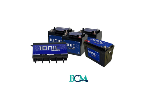
24V & 150Ah Ionic Lithium Boat Bundle
Sale price $2,097.00Regular price $2,366.00 -
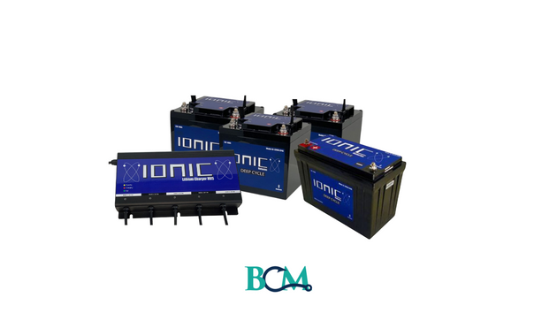
Vendor: Brushy Creek Marine
Ionic Lithium 36V Bass Boat Bundle - 3x 60Ah + 150Ah + 4-Bank Charger
Sale price $1,846.00Regular price $2,615.00 -

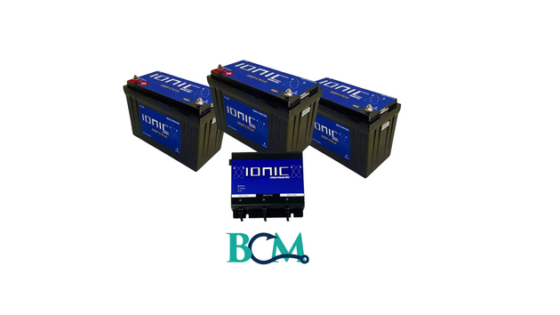
Vendor: Brushy Creek Marine
24V Ionic Lithium Battery Bundle
Regular price $967.00
![Lowrance ActiveTarget 2 XL Sonar w/Transducer [000-16488-001] - Premium Sounder/Sonar Modules from Lowrance - Just $1799! Shop now at Brushy Creek Marine](http://bcmarineproducts.com/cdn/shop/files/111981XL.jpg?v=1768500871&width=540)


Product Description
Navionics Vision+™ NVSA004L - Mexico, the Caribbean to Brazil - Inland & Coastal Marine Charts
It's A Whole New Look On Your Chartplotter
Featuring vibrant colors, a streamlined interface, and combined coastal/inland content with a popular Navionics® style color palette, Garmin Navionics+ cartography makes it easy to plot your course with the world’s No. 1 name in marine mapping1.
Features:
- Navigate with our best offshore and inland lake coverage for your Garmin chartplotter.
- See it your way. Customize your view with various chart layers and overlay combinations.
- With your included one-year subscription, access daily updates via the ActiveCaptain® smart-device app.
- Auto Guidance+™ technology2 lets you navigate with suggested dock-to-dock routings.
- Select up to 10 color-shaded target depth ranges to scope out the best fishing spots.
- Save money by renewing your subscription — and continue accessing daily updates plus new content downloads.
- Access detail-rich mapping of coastal features, lakes, rivers, and more. Integrated Garmin and Navionics® content offer coverage for boaters worldwide.
- Charts are constantly being enhanced with new and amended content — as many as 5,000 updates are made every day. Your one-year subscription includes access to daily chart updates via the ActiveCaptain app.
- Combining the best of Garmin and Navionics automatic routing features, built-in Auto Guidance+ technology2 gives you a suggested dock-to-dock path to follow through channels, inlets, marina entrances, and more.
- High-resolution depth range shading lets you select up to 10 color-shaded options and view your designated target depths at a glance.
- For improved fishing and navigation, up to 1' contours provide a clear depiction of bottom structure for improved fishing charts and enhanced detail in swamps, canals, harbors, marinas and more.
- To give a clear picture of shallow waters to avoid, this feature allows for shading at a user-defined depth.
- NOAA raster cartography3 is available for some U.S. waters as a free downloadable feature via the ActiveCaptain app to provide paper chart-like views on your plotter.
- Community-sourced content provides useful POIs, such as marinas, anchorages, hazards, businesses and more. Get recommendations from boaters with firsthand experience of the local environment.
- This downloadable shading feature4 combines color and shadow to give you an easy-to-interpret, clearer view of the bottom structure than contour lines alone.
- The downloadable sonar imagery feature4 reveals bottom hardness clearly and in contrasting colors, highlighting both subtle and dramatic transition areas on select U.S. lakes.
- Downloadable high-resolution satellite imagery4 provides superior situational awareness.
- Crystal-clear aerial and surface photos of ports, marinas, bridges, docks, boat ramps, dams, and navigational landmarks provide a better sense of your surroundings above the waterline.
- Side-scan images capture submerged features such as fallen timber, fish attractors, wrecks, potential hazards, and more on select U.S. lakes.
- This underwater perspective shows a 3D representation of the bottom and contours as seen from below the waterline. Interface with sonar data for a customized view.
- This view provides a 3D representation of the surrounding area both above and below the waterline.
- Adjust your maps to the lake’s current water levels to see if spots are accessible or too shallow to explore.
1 Based on 2021 reported sales
2 Auto Guidance+ is for planning purposes only and does not replace safe navigation operations
3 Raster cartography cannot be viewed on echoMAP™ CHIRP and ECHOMAP™ Plus combos but can be viewed on mobile devices via the ActiveCaptain mobile app
4 Subscription required; a one-year subscription, which is included with the purchase of Navionics Vision+ mapping solution, lets you access daily chart updates and download additional content or premium features included with your cartography product
Customer Reviews
Similar Products
-
![Lowrance ActiveTarget 2 XL Sonar w/Transducer [000-16488-001] - Premium Sounder/Sonar Modules from Lowrance - Just $1799! Shop now at Brushy Creek Marine](//bcmarineproducts.com/cdn/shop/files/111981XL.jpg?v=1768500871&width=630)
Vendor: Lowrance
Lowrance ActiveTarget 2 XL Sonar w/Transducer [000-16488-001]
Regular price $1,799.00 -
Vendor: Brushy Creek Marine
24V & 150Ah Ionic Lithium Boat Bundle
Sale price $2,097.00Regular price $2,366.00 -
Vendor: Brushy Creek Marine
Ionic Lithium 36V Bass Boat Bundle - 3x 60Ah + 150Ah + 4-Bank Charger
Sale price $1,846.00Regular price $2,615.00 -
Vendor: Brushy Creek Marine
24V Ionic Lithium Battery Bundle
Regular price $967.00
![Lowrance ActiveTarget 2 XL Sonar w/Transducer [000-16488-001] - Premium Sounder/Sonar Modules from Lowrance - Just $1799! Shop now at Brushy Creek Marine](http://bcmarineproducts.com/cdn/shop/files/111981XL.jpg?v=1768500871&width=630)


