
-
 files/116040XL.jpg
-
 files/116040BXL.jpg


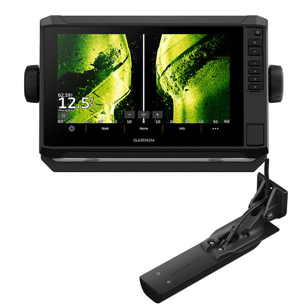
Garmin ECHOMAP Ultra 2 106sv with GT56UHD-TM & Navionics+, Remanufactured
Study charts and underwater structure on the Garmin ECHOMAP Ultra 2 106sv’s crisp, sunlight-readable 10-inch touchscreen. This chartplotter/fishfinder package combines Garmin Navionics+ inland and coastal mapping with an included GT56UHD-TM transducer for CHIRP traditional sonar and Ultra High-Definition ClearVü and SideVü scanning sonar.
Scout a new stretch of water, examine structure in vivid sonar colors and mark a waypoint for your next pass. The 1280 x 800 IPS display gives you room to review your fishing information, while touchscreen controls with keyed assist let you choose how to operate the unit.
Condition: Remanufactured. This is not a new-condition unit. The package includes the GT56UHD-TM transducer and Garmin Navionics+ inland and coastal mapping.
Key Features
- 10-inch touchscreen: WXGA IPS display with 1280 x 800 resolution and keyed assist.
- GT56UHD-TM transducer included: Access Garmin CHIRP traditional sonar and UHD ClearVü and SideVü scanning sonar.
- Vivid sonar color palettes: High-contrast colors help distinguish targets and underwater structure.
- Built-in Garmin Navionics+ maps: Inland and coastal coverage with depth range shading and support for Auto Guidance+ planning.
- Multi-band GPS: Multi-constellation positioning helps improve position accuracy.
- Wireless networking: Share supported sonar, waypoints and routes with compatible ECHOMAP Ultra 2 or ECHOMAP UHD2 chartplotters.
- LiveScope support: Expand with compatible LiveScope live-scanning sonar equipment, sold separately.
- Quick-release mounting: The bail mount with quick-release cradle makes the display easy to install and remove.
Connected Fishing System
Pair with the ActiveCaptain app on a compatible smart device for software updates, screen recording and Garmin Quickdraw Community data. Connect a compatible Force trolling motor wirelessly to navigate to waypoints and draw or follow routes. NMEA 2000 compatibility supports connections to compatible heading sensors, autopilots and Fusion-Link audio systems.
Optional Garmin Navionics Vision+ mapping adds features such as high-resolution relief shading and satellite imagery. Accessory sonar systems, trolling motors, network equipment and premium mapping are sold separately. Available functions depend on compatible connected equipment and system configuration.
Auto Guidance+ is for planning purposes only and does not replace safe navigation operations.
Display, Navigation & Memory
- Model: ECHOMAP Ultra 2 106sv
- Manufacturer part number: 010-N2880-01
- Condition: Remanufactured
- Display: 10-inch diagonal, WXGA IPS touchscreen
- Resolution: 1280 x 800 pixels
- Dimensions: 11.6 x 7.7 x 3.9 inches
- Unit weight: 4.0 lb
- Water rating: IPX7
- Mounting options: Bail or flush
- Memory card slots: 2 microSD
- Waypoints: 5,000
- Track points: 50,000
- Saved tracks: 50
- Navigation routes: 100
- GPS receiver: Built-in, 10 Hz, multi-band and multi-constellation
Power & Connections
- Power input: 9–18 VDC
- Typical current draw at 12 VDC: 2.5 A
- Maximum current draw at 12 VDC: 5.0 A
- Maximum power usage at 10 VDC: 36 W
- Sonar power output: 600 W
- NMEA compatibility: NMEA 2000 and NMEA 0183
- NMEA 2000 ports: 1
- Garmin Marine Network ports: 2, large connector
- Scanning sonar connection: 12-pin transducer port
- Wireless connectivity: Garmin Wi-Fi local network and ANT+
What’s Included
- ECHOMAP Ultra 2 106sv chartplotter with Garmin Navionics+ inland and coastal mapping
- GT56UHD-TM transducer
- Power/data cable
- Bail mount with quick-release cradle
- Protective sun cover
- Hardware
- Documentation
Garmin
Garmin ECHOMAP Ultra 2 106sv w/GT56UHD-TM Transducer - Garmin Navionics+ *Remanufactured [010-N2880-01]
- Regular price
- $2,499.99
Garmin ECHOMAP Ultra 2 106sv with GT56UHD-TM & Navionics+, Remanufactured
Study charts and underwater structure on the Garmin ECHOMAP Ultra 2 106sv’s crisp, sunlight-readable 10-inch touchscreen. This chartplotter/fishfinder package combines Garmin Navionics+ inland and coastal mapping with an included GT56UHD-TM transducer for CHIRP traditional sonar and Ultra High-Definition ClearVü and SideVü scanning sonar.
Scout a new stretch of water, examine structure in vivid sonar colors and mark a waypoint for your next pass. The 1280 x 800 IPS display gives you room to review your fishing information, while touchscreen controls with keyed assist let you choose how to operate the unit.
Condition: Remanufactured. This is not a new-condition unit. The package includes the GT56UHD-TM transducer and Garmin Navionics+ inland and coastal mapping.
Key Features
- 10-inch touchscreen: WXGA IPS display with 1280 x 800 resolution and keyed assist.
- GT56UHD-TM transducer included: Access Garmin CHIRP traditional sonar and UHD ClearVü and SideVü scanning sonar.
- Vivid sonar color palettes: High-contrast colors help distinguish targets and underwater structure.
- Built-in Garmin Navionics+ maps: Inland and coastal coverage with depth range shading and support for Auto Guidance+ planning.
- Multi-band GPS: Multi-constellation positioning helps improve position accuracy.
- Wireless networking: Share supported sonar, waypoints and routes with compatible ECHOMAP Ultra 2 or ECHOMAP UHD2 chartplotters.
- LiveScope support: Expand with compatible LiveScope live-scanning sonar equipment, sold separately.
- Quick-release mounting: The bail mount with quick-release cradle makes the display easy to install and remove.
Connected Fishing System
Pair with the ActiveCaptain app on a compatible smart device for software updates, screen recording and Garmin Quickdraw Community data. Connect a compatible Force trolling motor wirelessly to navigate to waypoints and draw or follow routes. NMEA 2000 compatibility supports connections to compatible heading sensors, autopilots and Fusion-Link audio systems.
Optional Garmin Navionics Vision+ mapping adds features such as high-resolution relief shading and satellite imagery. Accessory sonar systems, trolling motors, network equipment and premium mapping are sold separately. Available functions depend on compatible connected equipment and system configuration.
Auto Guidance+ is for planning purposes only and does not replace safe navigation operations.
Display, Navigation & Memory
- Model: ECHOMAP Ultra 2 106sv
- Manufacturer part number: 010-N2880-01
- Condition: Remanufactured
- Display: 10-inch diagonal, WXGA IPS touchscreen
- Resolution: 1280 x 800 pixels
- Dimensions: 11.6 x 7.7 x 3.9 inches
- Unit weight: 4.0 lb
- Water rating: IPX7
- Mounting options: Bail or flush
- Memory card slots: 2 microSD
- Waypoints: 5,000
- Track points: 50,000
- Saved tracks: 50
- Navigation routes: 100
- GPS receiver: Built-in, 10 Hz, multi-band and multi-constellation
Power & Connections
- Power input: 9–18 VDC
- Typical current draw at 12 VDC: 2.5 A
- Maximum current draw at 12 VDC: 5.0 A
- Maximum power usage at 10 VDC: 36 W
- Sonar power output: 600 W
- NMEA compatibility: NMEA 2000 and NMEA 0183
- NMEA 2000 ports: 1
- Garmin Marine Network ports: 2, large connector
- Scanning sonar connection: 12-pin transducer port
- Wireless connectivity: Garmin Wi-Fi local network and ANT+
What’s Included
- ECHOMAP Ultra 2 106sv chartplotter with Garmin Navionics+ inland and coastal mapping
- GT56UHD-TM transducer
- Power/data cable
- Bail mount with quick-release cradle
- Protective sun cover
- Hardware
- Documentation
- Regular price
- $2,499.99


Frequently Bought Together
-

Vendor: Garmin
Garmin Force Freshwater Trolling Motor - 57" [010-02025-00]
Regular price $3,649.99 -

Vendor: Garmin
Garmin ECHOMAP UHD2 93sv Chartplotter Fishfinder Combo with US Inland Maps & GT56UHD-TM
Regular price $1,299.99 -

Vendor: Garmin
Garmin Force Trolling Motor Propeller Mounting Kit [S00-01000-28]
Regular price $19.99 -

Vendor: Garmin
Garmin LiveScope 2 HD Transducer - LVS42HD [010-03899-00]
Regular price $2,199.99


Product Description
Garmin ECHOMAP Ultra 2 106sv with GT56UHD-TM & Navionics+, Remanufactured
Study charts and underwater structure on the Garmin ECHOMAP Ultra 2 106sv’s crisp, sunlight-readable 10-inch touchscreen. This chartplotter/fishfinder package combines Garmin Navionics+ inland and coastal mapping with an included GT56UHD-TM transducer for CHIRP traditional sonar and Ultra High-Definition ClearVü and SideVü scanning sonar.
Scout a new stretch of water, examine structure in vivid sonar colors and mark a waypoint for your next pass. The 1280 x 800 IPS display gives you room to review your fishing information, while touchscreen controls with keyed assist let you choose how to operate the unit.
Condition: Remanufactured. This is not a new-condition unit. The package includes the GT56UHD-TM transducer and Garmin Navionics+ inland and coastal mapping.
Key Features
- 10-inch touchscreen: WXGA IPS display with 1280 x 800 resolution and keyed assist.
- GT56UHD-TM transducer included: Access Garmin CHIRP traditional sonar and UHD ClearVü and SideVü scanning sonar.
- Vivid sonar color palettes: High-contrast colors help distinguish targets and underwater structure.
- Built-in Garmin Navionics+ maps: Inland and coastal coverage with depth range shading and support for Auto Guidance+ planning.
- Multi-band GPS: Multi-constellation positioning helps improve position accuracy.
- Wireless networking: Share supported sonar, waypoints and routes with compatible ECHOMAP Ultra 2 or ECHOMAP UHD2 chartplotters.
- LiveScope support: Expand with compatible LiveScope live-scanning sonar equipment, sold separately.
- Quick-release mounting: The bail mount with quick-release cradle makes the display easy to install and remove.
Connected Fishing System
Pair with the ActiveCaptain app on a compatible smart device for software updates, screen recording and Garmin Quickdraw Community data. Connect a compatible Force trolling motor wirelessly to navigate to waypoints and draw or follow routes. NMEA 2000 compatibility supports connections to compatible heading sensors, autopilots and Fusion-Link audio systems.
Optional Garmin Navionics Vision+ mapping adds features such as high-resolution relief shading and satellite imagery. Accessory sonar systems, trolling motors, network equipment and premium mapping are sold separately. Available functions depend on compatible connected equipment and system configuration.
Auto Guidance+ is for planning purposes only and does not replace safe navigation operations.
Display, Navigation & Memory
- Model: ECHOMAP Ultra 2 106sv
- Manufacturer part number: 010-N2880-01
- Condition: Remanufactured
- Display: 10-inch diagonal, WXGA IPS touchscreen
- Resolution: 1280 x 800 pixels
- Dimensions: 11.6 x 7.7 x 3.9 inches
- Unit weight: 4.0 lb
- Water rating: IPX7
- Mounting options: Bail or flush
- Memory card slots: 2 microSD
- Waypoints: 5,000
- Track points: 50,000
- Saved tracks: 50
- Navigation routes: 100
- GPS receiver: Built-in, 10 Hz, multi-band and multi-constellation
Power & Connections
- Power input: 9–18 VDC
- Typical current draw at 12 VDC: 2.5 A
- Maximum current draw at 12 VDC: 5.0 A
- Maximum power usage at 10 VDC: 36 W
- Sonar power output: 600 W
- NMEA compatibility: NMEA 2000 and NMEA 0183
- NMEA 2000 ports: 1
- Garmin Marine Network ports: 2, large connector
- Scanning sonar connection: 12-pin transducer port
- Wireless connectivity: Garmin Wi-Fi local network and ANT+
What’s Included
- ECHOMAP Ultra 2 106sv chartplotter with Garmin Navionics+ inland and coastal mapping
- GT56UHD-TM transducer
- Power/data cable
- Bail mount with quick-release cradle
- Protective sun cover
- Hardware
- Documentation
Customer
Reviews
Similar Products
-


Vendor: Garmin
Garmin Force Freshwater Trolling Motor - 57" [010-02025-00]
Regular price $3,649.99 -

Vendor: Garmin
Garmin ECHOMAP UHD2 93sv Chartplotter Fishfinder Combo with US Inland Maps & GT56UHD-TM
Regular price $1,299.99 -

Vendor: Garmin
Garmin Force Trolling Motor Propeller Mounting Kit [S00-01000-28]
Regular price $19.99 -

Vendor: Garmin
Garmin LiveScope 2 HD Transducer - LVS42HD [010-03899-00]
Regular price $2,199.99


